FAIR is a non-profit organization dedicated to providing well-documented answers to criticisms of the doctrine, practice, and history of The Church of Jesus Christ of Latter-day Saints.
File:Holley Geography 1.png
No higher resolution available.
Holley_Geography_1.png (622 × 480 pixels, file size: 65 KB, MIME type: image/png)
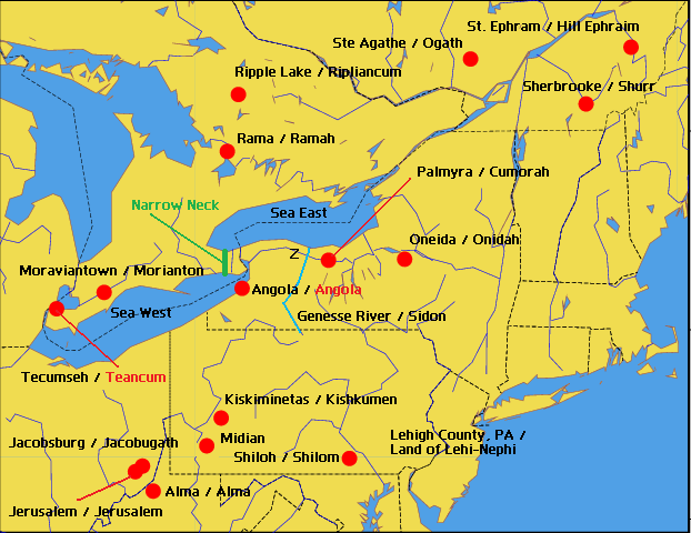
Map of Vernal Holley's proposed geography of Book of Mormon locations with supposed correspondences to New England and Canada places of 19th century. From Vernal Holley, Book of Mormon Authorship, 3rd edition, Revised and Enlarged (Roy, Utah: self-published, 1992). Based on information reproduced at http://www.mazeministry.com/mormonism/holley/holleymaps.htm.
This graphic is (C) 2008 FAIR; no unauthorized reproduction is permitted without written permission from the FAIR board.
File history
Click on a date/time to view the file as it appeared at that time.
| Date/Time | Thumbnail | Dimensions | User | Comment | |
|---|---|---|---|---|---|
| current | 01:25, 28 October 2008 | | 622 × 480 (65 KB) | GregSmith (talk | contribs) | |
| 01:19, 28 October 2008 |  | 622 × 480 (65 KB) | GregSmith (talk | contribs) | ||
| 01:17, 28 October 2008 |  | 622 × 480 (65 KB) | GregSmith (talk | contribs) | ||
| 01:10, 28 October 2008 |  | 622 × 480 (64 KB) | GregSmith (talk | contribs) | ||
| 00:45, 28 October 2008 |  | 622 × 480 (64 KB) | GregSmith (talk | contribs) | ||
| 00:43, 28 October 2008 |  | 622 × 480 (64 KB) | GregSmith (talk | contribs) | ||
| 00:42, 28 October 2008 |  | 622 × 480 (64 KB) | GregSmith (talk | contribs) | ||
| 23:57, 27 October 2008 | 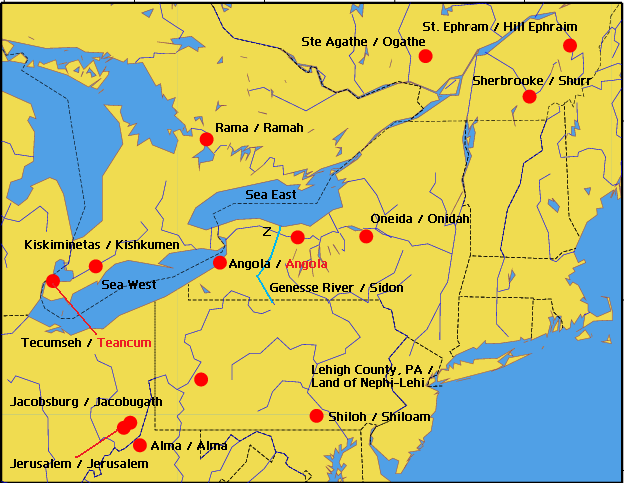 | 624 × 483 (64 KB) | GregSmith (talk | contribs) | Map of Vernal Holley's proposed geography of Book of Mormon locations with supposed correspondences to New England and Canada places of 19th century. From Vernal Holley, Book of Mormon Authorship, 3rd edition, Revised and Enlarged (Roy, Utah: self-publis |
- You cannot overwrite this file.
File usage
There are no pages that link to this file.